So, we departed Bifröst by turning left onto the Ring Road for the first time ever and headed off into the unknown. A few miles north of Bifröst we reached our first fork in the road and the kids chose to turn left, putting us onto highway 60. The mountainous terrain we passed through was quite impressive with waterfalls around every bend. We topped out at about 1400 feet above sea level at Brattabrekka pass. Continuing down the other side, we soon came to Breiðafjörður, which is the bay between Vestfirðir and Snæfellsnes. The Vestfirðir (West Fjords) is the large claw of land that extends to the northwest of Iceland and Snæfellsnes is the long, narrow peninsula that is south of the Vestfirðir. Breiðafjörður means "wide fjord," which makes sense, given its location and breadth.
 |
| Art deco-era American sculpture of Leifur Eiriksson at the bow of his boat, discovering North America. |
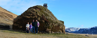
We drove north up the coast a short distance and ate dinner at the grill in the grocery store in Búðardalur, because all of the other restaurants were still closed for the winter. We then drove back down the coast and up the Haukadalur valley to visit Eiriksstaðir, which means Eirik's place. The Eirik in question is Eirik the Red, the father of Leifur Eiriksson, who is probably the most famous historical Icelander in the U.S. Eirik was living at this site when Leifur was born, but quarrels with his neighbors led to his exile, so he moved his family out onto some islands in Breiðafjörður. More quarrels and killings led to his further exile and Eirik decided to head further west, having heard stories of land sightings from Vikings who had been blown off course and ended up near Greenland. The rest is history, so to speak, because Eirik was successful in establishing colonies of Icelanders in Greenland and Leifur the Lucky explored further afield and discovered the east coast of North America. He got at least as far south as Newfoundland and some scholars speculate that Greenlanders may have gotten as far as
 Long Island, based on descriptions of the lands as preserved in various sagas. Thinking of these exploits as I stood in the excavated remains of the longhouse with the kids, I found it to be quite intriguing to be at the exact spot where a man was born over 1000 years ago, who managed to venture that far afield using only the rudimentary technology that was available to medieval Viking sailors.
 |
| Reconstructed longhouse from the Viking Age, traditionally made of stone, turf, and driftwood. |
 |
| The sixty mile long northern coast of Snæfellsnes, with Snæfellsjökull on the far right. |
 |
| View across the mouth of Hvammsfjörður, to the mainland at Fellsströnd. |
 A short distance beyond the mouth of Hvammsfjörður is the port town of Stykkishólmur, from which ferries leave daily to cross Breiðafjörður and dock in the Vestfirðir. We did not have time to take a ferry, but we definitely look forward to doing that in the future. Instead, we climbed a hill at the docks to take one last look at Breiðafjörður before heading towards home.
We took the paved road south out of Stykkishólmur and across the peninsula. We hit a pretty good snow squall going over the top, but the drive only took 20 minutes coast-to-coast! We headed back east on the south side of Snæfellsnes until we got to Borgarnes. Then, we took our well-travelled route back home. It was great to finally see more of the area around Bifröst. Nothing we saw is very far from home. Even Stykkishólmur, the furthest point from Bifröst in our route, is only an hour and a half drive away, so we can easily see many of these sights again when we have the time and the weather cooperates.


No comments:
Post a Comment